Up "The Ben" (Skrevet av helen 23.06.2008) Tur foretatt: Juni 2008. Ben Nevis is refered to as The Ben by all the locals. Ben is Gaelic for mountain.
I had to start off my national peak collection this summer with my native national peak, though I still think that the UK should be divided into the four countries. An opinion that is shared by several other British people of my acquaintance.
I got a cheap flight to Prestwick and hired a car to drive up to Fort William. In fact, the starting point for the walk is only about 2 km out of town, so I could have used public transport all the way. I stayed at a bunkhouse near the start of the track. I shared my room with a Scottish mountaineering club who were celebrating one of their members climbing their last Munro. Munros are Scottish mountains over 3000ft. There are 277 of them and to climb all of them is a feat Scottish mountaineers aspire to. They suggested many great Munros to climb, but unfortunately as they all had obscure Gaelic names, I can't remember any of them now.
I started off from the Information Centre in Glen Nevis. The Information Centre is manned by a friendly, chatty and knowledgeable Scottish park ranger. I can recommend stopping by for a chat with him about Ben Nevis or other peaks.
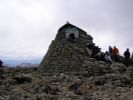
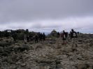
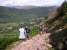
The track from the Info Centre follows the old pony track to the observatory that was built at the top in the 1800s. It is paved and easy to walk up, but a killer on the knees and ankles on the way down. The path rounds the flank of the mountain and then goes in switch-backs up towards the summit. The path is well-marked and not too steep to those used to Norwegian mountains, however the top plateau is notoriously difficult to navigate in bad weather. Ben Nevis is covered on thick cloud for on average 255 days a year. I was very lucky as it was sunny and virtually cloud free when I was there, but the path is harder to follow at the top and there are steep cliffs on either side, so I can imagine it easily become dangerous on bad day.
As it was such a nice day, there were hundreds and hundreds of people walking up. Some places I had to walk in line. Some were better prepared than others for the walk. Despite there being information and warnings everywhere on safety on the mountain, there were still people heading up in only shorts and t-shirts and without water.
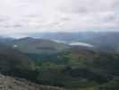
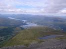
The cloud cleared as I was leaving the top so I had great views northwards to Skye on the way down. I met lots of nice people - British people are easy to get chatting to, and I didn't get too badly bitten by midges. So all in all it was a good day. It took 4 hours up and 3 hours down. Tilbake til Storbritannia og Nord-Irland